

Canada
⎪CANADA
Canada is home to more than a million acres of pristine wilderness. Its vast inventory of jagged peaks, U-shaped valleys, thick green forests, and braided streams of milky glacier water remind one of Switzerland, but on a grander scale and with far less development. Much like Alaska, the western provinces are littered with snowy summits as far as the eye can see. In winter and spring they are split vertically with untracked lines of the kind that once routinely graced the covers of ski magazines. Huge expanses of old-growth forest lie at their feet, creating formidable natural barriers through which only the hardiest of outdoorsmen (and women) can penetrate. Hundreds, perhaps thousands of mineral-laden turquoise lakes frozen white in winter mark the boundaries between the forest and the alpine. It is a landscape of mind-bending beauty. Its climate is cold and dry (beyond the Coast Mountains at least), and its wintertime precipitation is reliably heavy. The topography is rich, varied, and often steep. The only major drawback to backcountry skiing in Canada—if there is one—is a lack of infrastructure, as there are few major roads/airports/population centers amidst the high peaks of the western provinces. For some, this is a good thing. For the rest of us mere mortals, it can be rather prohibitive. Below are a few of the more well known (i.e.: accessible) lines in Canada. By no means is this an exhaustive list, as it would take more than a lifetime to ski and document all of Canada’s biggest lines. But one has to start somewhere.
⎪CANADA | Gallery
—click on images to enlarge
⎪CANADA | The Biggest Lines
• SYMBOLS KEY: Click on the ⚲ symbol for location on Google Maps; info for trip reports; the ▸ symbol for video links; and STRAVA for Strava link/route info
• RATINGS KEY: Exposure: E1=Low, E2=Medium, E3=High, E4=Extreme Distance: S=Slack, R=Remote, VR=Very Remote, XR=Extremely Remote Max Slope Angle: XX°
• UPDATES: while serious hazards exist on all Biggest Lines ski routes, these route updates provide additional beta from new developments and/or recent trip reports
99. ¾ Couloir, Moraine Lake, Banff National Park, AB ⚲ info info ▸ ▸ E3/R/45°
100. Aemmer Couloir, Mt. Temple, Banff National Park, AB ⚲ info info info ▸ ▸ ▸ E3/R/45°
101. Central Couloir, Northwest Face, Joffre Peak, Permberton, Coast Range, BC ⚲ info ▸ ▸ STRAVA E4+/XR/56°
route update: thin snowpack and dangerously volatile landscape; recent landslide has significantly altered exit, making this route effectively unskiable. The SE facing Aussie Couloir [E2/VR/42°] is the preferred line, with relatively easy approach/egress and few objective hazards
102. Combatant Couloir, Mt. Combatant, Waddington Coast Range, BC ⚲ info info ▸ E4/XR/63°
103. Forever Young Couloir, Glacier National Park, Rogers Pass, BC ⚲ info ▸ ▸ STRAVA E3/VR/40°
104. Mount Currie, Pencil & Central Couloirs, Mt. Currie, Pemberton, BC ⚲ info ▸ ▸ E3+/VR/45°+
105. Mount Sifton, Rogers Pass, BC ⚲ info info ▸ STRAVA E3/VR/40°+
106. North Bowl, Revelstoke, BC info info info STRAVA E3/S/45°+ (with a vertical of 1828m, the longest piste in North America)
107. Owls Couloir/Owl's Jr., The Owls, Wedgemount Group, Pemberton, BC ⚲ info ▸ fatmap fatmap E3/VR/61 E4/VR/53°
108. Narrow Minded Couloir, Mt. Beluga, Baffin Island, Nunavut ⚲ info info ▸ E3/XR+/50°+
109. North Couloir, Copper Peaks, Rogers Pass, BC ⚲ info info ▸ E3/XR/40°+
110. North Face, Mt. Robson, BC ⚲ info info info ▸ ▸ E4+/XR+/50°+
route update: only two known descents on this extremely dangerous, almost unskiable route
111. Polar Star Couloir, Mt. Beluga, Baffin Island, Nunavut ⚲ info info info info info ▸ STRAVA E3/XR+/54°
112. Saudan Couloir (Couloir Extreme), Whistler, BC info info info info STRAVA E3/S/49°
113. X Couloir, Mt. Whymper, Bow Valley, BC ⚲ info info info info ▸ E4/XR+/45°+
BONUS LINE: Comstock Couloir, Mount Dawson, Selkirk Range, British Columbia, CA ⚲ info info ▸
route update: very rarely in condition; significant rock, avalanche, fall hazards
*IMPORTANT: Exposure Level and Distance ratings are subjective and do not adequately reflect dangers inherent on approach or egress. Use conservatively.
⎪CANADA | Maps

CANADA
-
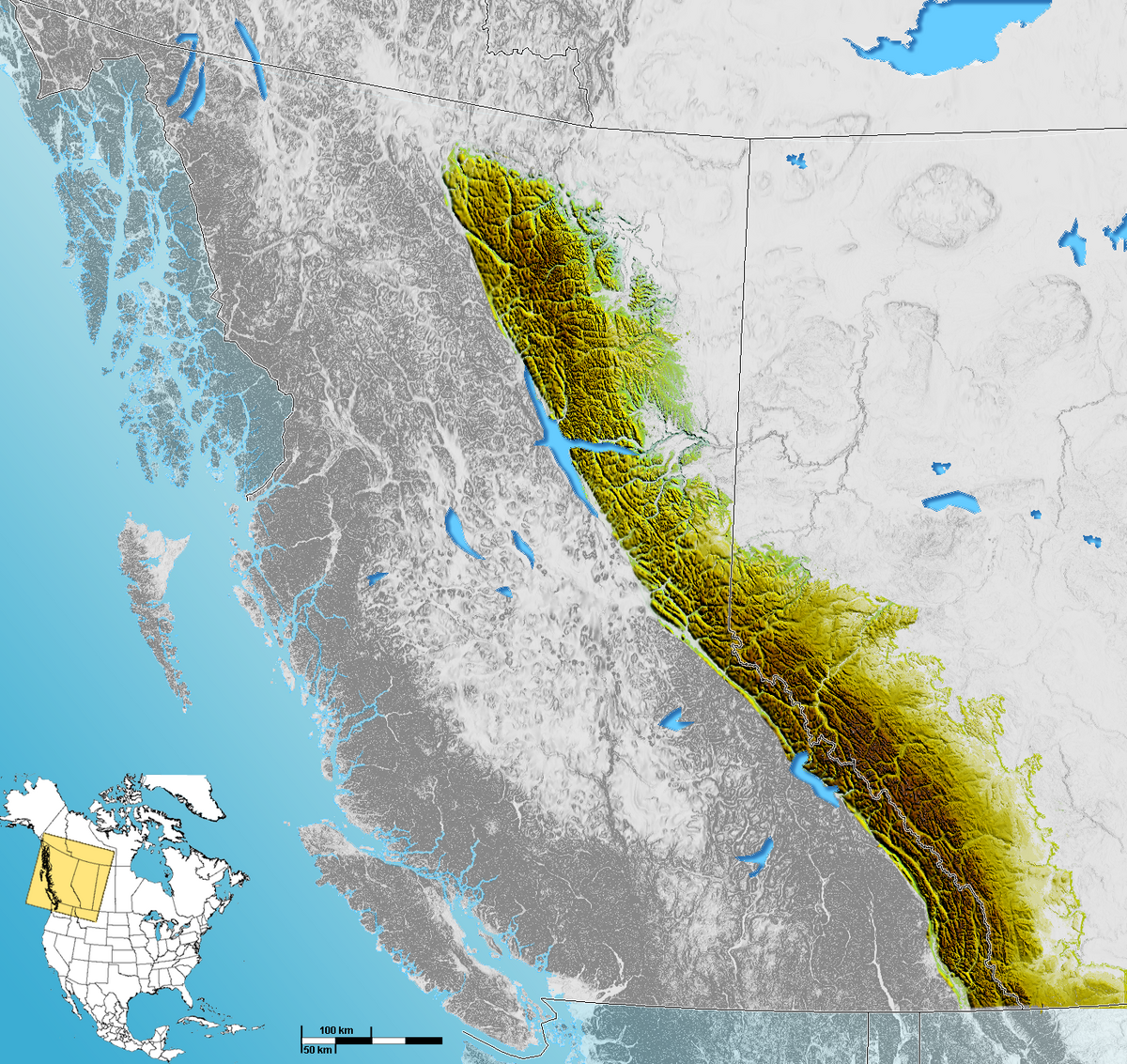
The Coast Range is the mountainous area situated along the western coast of British Columbia, stretching all the way from the Fraser River valley in the south to the Alaska Panhandle in the north. Covered in dense temperate rainforest on its western exposures, the range rises to heavily glaciated peaks, including the largest temperate-latitude ice fields in the world (which can be seen rather clearly on the map). Separated by a vast Interior Plateau and the Rocky Mountain Trench, the Canadian Rockies are the obvious north-south line of mountains just to the east, straddling the provincial borders of British Columbia and Alberta. The Columbia Mountains (including the Monashees, Selkirks, and Purcells) on the western flank of the Trench, make up the southern and western portions of this high terrain, but are geologically distinct from the the Canadian Rockies. Both ranges see heavily glaciated peaks, U-shaped valleys, heavy precipitation, and dry mountain air, which all lend themselves to excellent conditions for steep skiing and snowboarding. Click on image for Google Map.
Relief map of Western Canada/British Columbia (Blue Green Atlas)
Canadian Rockies (Wikipedia)
Rogers Pass Backcountry Access Map (photo: Parks Canada)